If you can’t see the tree layer and your Google Earth user interface is other than English, change the language to US English and the Trees show up in the 3D buildings options http://earth.google.com/support/bin/static.py?page=guide.cs&guide=22358&topic=22360&answer=148181
Month: November 2010
Review of GE 3D Trees
I have been expecting 3D trees in Google Earth for years. I am just surprised that the 3D trees look relatively ugly (1990ies computer graphics). But it is indeed a step towards landscape visualization.
In fall 2008, Microsoft’s globe formally known as “Virtual Earth” got some nicer 3D trees from SpeedTree. But they only included a few cities such as parts of Miami.
Paar and Clasen (2007) describe a landscape scenery globe focusing on complex 3D vegetation cover, including shrub, grass and herb layers.
Currently, in GE 6, there are some misplaced trees (not there in reality or placed in the middle of roads). I am wondering when Google will add tools to SketchUp and GE for planting trees. Then I guess users will ask how to distribute larger areas of plants. This is was ArcGIS users and Biosphere3D users have always been asking us.
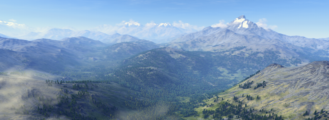
GoogleEarth 6 plants 3D trees
Google published version 6 of GoogleEarth and the most important update for our profession is that it comes with 3D trees!
However, not the whole Earth is populated with trees yet but only some areas in a few selected cities: According to TechCrunch 80 million trees were “planted” in Athens, Berlin, Chicago, New York City, San Francisco and Tokyo. Yet, the quality of trees is rather low but Google claims to distinguish 50 species already. Other updates of version 6 include an enhanced integration of StreetView and a more user-friendly overview and navigation through historic aerial images. The new version is a beta and does not update automatically but must be installed from the Google download site. A GoogleEarth showcase can be downloaded here.
The key question for us is how the integration may facilitate the use of GoogleEarth as a tool in landscape related design and planning professions. Sheppard and Cizek (2009) discussed the various technical and ethical issues of previous GoogleEarth versions and identified the lack of vegetation as one of the major limitations. Our tests in the Kimberley Climate Adaptation Project supported the argument that the lack of vegetation distorts the representation of future design scenarios in GoogleEarth and inhibits the otherwise potentially useful tool for landscape planning.
In this context, the new GoogleEarth version allows new user tests and applications. Next steps could be to explore how 3D trees are inserted and distributed, assessments how realistic GoogleEarth forest stands are, and how user´s landscape perception will change with regard to Google´s “Tree View”. As one of the first new applications, Google.org is planning to use the virtual trees to push (real) reforestation campaigns.
Autodesk // Labs_ Project Galileo
Project Galileo will be previewed at Autodesk University, Dec 1st, 2010. Galileo is an easy-to-use planning tool for creating 3D city models from civil, geospatial and building data, and 3D models. Galileo also enables users to sketch conceptual infrastructure ideas within the 3D city model. Using Galileo, planners, GIS analysts, project managers, and architects can help stakeholders better understand infrastructure projects and plans in the context of the built and natural environment.
Check: http://atlandsend.typepad.com/at-lands-end/
Is it based on the LandXplorer framework?
OpenStreetMap makes Bing!
OpenStreetMap (OSM) project founder Steve Coast has announced that he has joined Microsoft to work on its Bing Maps team. According to Coast, Microsoft will be providing access to its “global orthorectified aerial imagery to help OpenStreetMappers make the map even better than it already is”.
Call for Papers – AGIT Exhibition and Conference 2011
Salzburg July 6-8, 2011
AGIT is a well established conference where every year many members of the German-speaking geoinformation community come together. Now the call for papers for 2011 will open from December 1, 2010 to February 1, 2011.
Themes in 2011 will be:
- Nature and landscape, climate and hydrology
- HealthGIS
- Sustainable energies, water management and spatial planning
- Mobility
- geoGovernment
- GeoMES: Catastrophe management
- Geoinformation in infrastructure management
Methods and Technologies
- 3-D models and cartographic communication
- Geomatics, remote sensing and image processing
- Mobile and location based services
- Dynamic modeling and simulation
- INSPIRE: Geoinfrastructure
- VGI and OpenSource geoinformation software
- Real time forum: Best practice
For more information and registration please see www.agit.at
Autodesk// Labs_ Project VASARI – Conceptual design and analysis for buildings
Download and check out this technology preview:
“Autodesk® Project Vasari is an easy-to-use, expressive design tool for creating building concepts. Vasari goes further, with integrated analysis for energy and carbon, providing design insight where the most important design decisions are made. And, when it’s time to move the design to production, simply bring your Vasari design data into the Autodesk® Revit® platform for BIM, ensuring clear execution of design intent.
Project Vasari is focused on conceptual building design using both geometric and parametric modeling. It supports performance-based design via integrated energy modeling and analysis features. This new technology preview is now available as a free download and trial on Autodesk Labs.”
Sounds like a sort of SketchUp with Add-ons for BIM and analysis. VASARI is based on the Revit framework but with a different GUI.